
![]()
![]()
![]()
Click on the images below to open the gallery and view them full-size.


Welcome to the tenth episode of the Global History Podcast. Today, we’d like to welcome David M. Carballo, Assistant Provost for General Education and Associate Professor of Archaeology, Anthropology, and Latin American Studies at Boston University. In his own words, Professor Carballo “is a specialist in Mesoamerican archaeology, focusing particularly on the prehispanic civilizations of central Mexico. Currently ongoing projects at the ancient city of Teotihuacan include the Proyecto Arqueológico Tlajinga, Teotihuacan (PATT), and the Proyecto Plaza de las Columnas”. His academic interests include “households, ritual, political evolution, urbanism, cooperation and conflict, craft production and exchange, GIS, archaeometry, and lithic analysis”.
He is the author of Obsidian and the Teotihuacan State: Weaponry and Ritual Production at the Moon Pyramid (2011), Cooperation and Collective Action: Archaeological Perspectives (2013), and Urbanization and Religion in Ancient Central Mexico (2016), and the co-editor of Obsidian Reflections: Symbolic Dimensions of Obsidian in Mesoamerica (2014). His most recent book is Collision of Worlds: A Deep History of the Fall of Aztec Mexico and the Forging of New Spain (2020), which will be published by Oxford University Press this July.
About a week ago, Chase spoke with Professor Carballo over skype about this new book, which foregrounds an approach to history over the long term. This is a perspective which takes into account centuries and even millennia of archaeological and historical developments across such areas as warfare and weaponry, plant and animal domestication, and trade and exchange, inviting us to view the Conquest of Mexico and the forging of New Spain on a broader temporal canvas. Listen on to find out more.
If you have any thoughts, questions, or comments about this episode, or would like to pitch us an idea for a new episode, feel free to email us at theglobalhistorypodcast@gmail.com, or send us a message on our website’s contact form, facebook, twitter, or instagram. If you would like to consult further resources on global history, feel free to visit our ‘Further Resources‘ page.
IMAGE 1: Book Cover, David M. Carballo, Collision of Worlds: A Deep History of the Fall of Aztec Mexico and the Forging of New Spain (Oxford University Press, 2020). Thank you to Jenny Rossberg for providing the image of this cover, and for Stefan Vranka for permitting its use here (both of Oxford University Press).
IMAGE 2: Mesoamerican Monumental Architecture. ‘Pyramid of the Sun, Teotihuacan’, Mexico. 100-250 CE. Description: “This great pyramid, one of the largest pre-Hispanic structures in the Americas, looms over the grid-plan city of Teotihuacan. This city dominated central Mexico from the first to the ninth centuries, when the city was burned and slowly abandoned. But the city was never forgotten. Although a ruin, it was well known to the Aztecs, who built their capital city of Tenochtitlan only about 40 kilometers away. It was they who gave the name Teotihuacan to the site, “City of the Gods,” believing that their present world had been created by self-sacrificing deities in the ancient city. Like the earlier urban behemoth, Tenochtitlan also had a grid plan, and Aztec city planners may have been inspired by Teotihuacan.” Dana Leibsohn and Barbara E. Mundy, Vistas: Visual Culture in Spanish America, 1520-1820, Vistas Gallery.
IMAGE 3: ‘View of Teotihuacan looking south from the Moon Pyramid to the Sun Pyramid and Street of the Dead’, in Collision of Worlds, Plate 2a. Photograph: David M. Carballo. The reproduction of this image in Collision of Worlds is authorized by the Instituto Nacional de Antropología e Historia, Mexico. Thank you to Prof. Carballo for providing this image.
IMAGE 4: A Roman Inheritance. ‘Acueducto romano de Segovia’ (Roman Aqueduct of Segovia), c. 50 BC. Photograph: Jesusccastillo. ‘This is a photo of a monument indexed in the Spanish heritage register of Bienes de Interés Cultural under the reference RI-51-0000043.’ Downloaded from Wikimedia Commons. Creative Commons Attribution-ShareAlike 3.0 Spain (CC BY-SA 3.0 ES).
IMAGE 5: Islamic Influences in Spain. ‘Seville and Guadalquivir river with Islamic tower (the Tower of Gold) in foreground and minaret in background, both with later Christian additions’, in Collision of Worlds, Plate 3b. Photograph: David M. Carballo. Thank you to Prof. Carballo for providing this image.
IMAGE 6: An influential symbol of the ‘reconquista’. ‘Santiago Matamoros. Lateral de la [I]glesia de Santiago, Valladolid. c. 1500.’ Photograph: Luis Fernández García. Downloaded from Wikimedia Commons. Creative Commons Attribution-ShareAlike 4.0 International (CC BY-SA 4.0).
IMAGE 7: A Spanish Dominican friar’s depiction of the founding of Tenochtitlan. Diego Durán, Codex Durán (The History of the Indies of New Spain), c. 1581. Downloaded from Latin American Studies.
IMAGE 8: An indigenous Mesoamerican artist’s depiction of the founding of Tenochtitlan. ‘Codex Mendoza, Foundation of Tenochtitlan’, 1535-1550 CE. Current location: Bodleian Library, Oxford, United Kingdom. Description: “This painted manuscript page depicts the foundation of the Aztec capital city, Tenochtitlan. The painting is the first, and one of the most elaborate, images in the Codex Mendoza. The Codex was created by indigenous painters in the mid-16th century, probably at the behest of the first Viceroy of New Spain, Antonio de Mendoza. It recalls and documents imperial tribute lists, royal history, and practices of daily life among the pre-Hispanic Aztec.” Dana Leibsohn and Barbara E. Mundy, Vistas: Visual Culture in Spanish America, 1520-1820, Vistas Gallery.
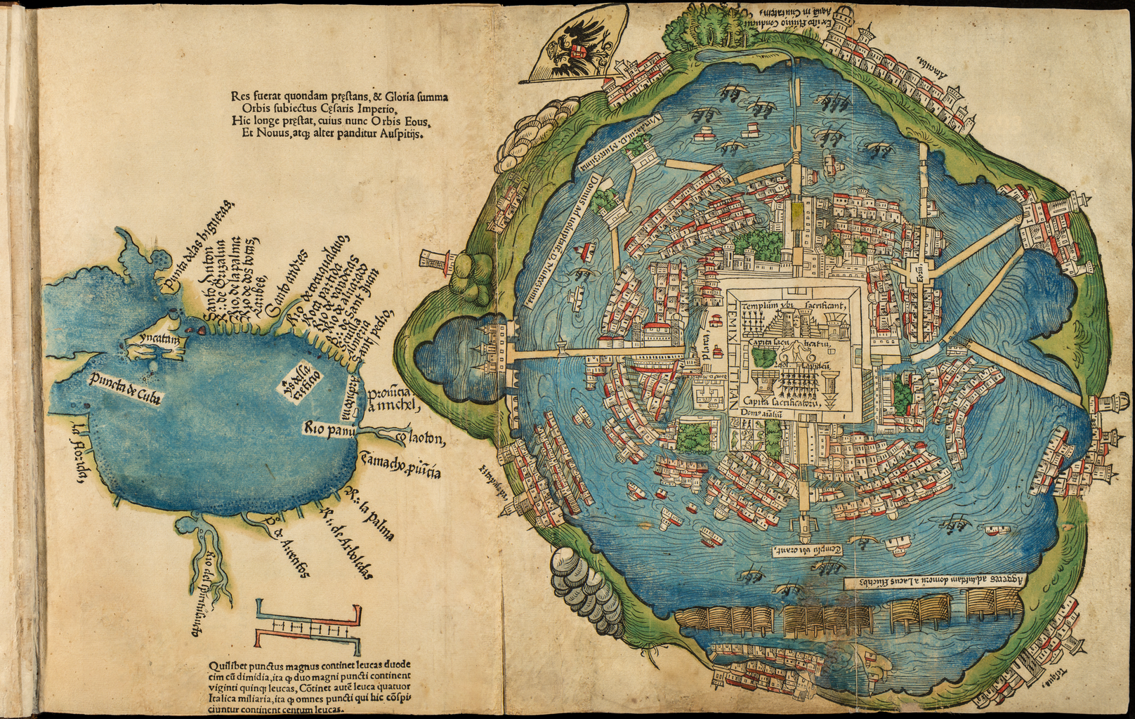
IMAGE 9: Map of Tenochtitlán from the first Latin edition of the Second Letter of Hernán Cortés to Emperor Charles V, 1524. Description: “Between July 1519 and September 1526, Hernán Cortés (1485‒1547), the soldier and adventurer who in 1519‒21 conquered for Spain what is now central and southern Mexico, sent five extended letters to Emperor Charles V in which he described his exploits and placed himself and his actions in a favorable light. This book contains the first Latin edition of Cortés’s second letter. In it, Cortés gives an account of his first meeting with the Aztec emperor, Montezuma II (whom he calls Moctezuma), and describes the vast extent and richness of his empire. Dated October 30, 1520, the letter was translated from Spanish into Latin by Petrus Savorgnanus and printed in Nuremberg, Germany, in 1524. This printing also contains the first published plan of the Aztec city of Tenochtitlán (present-day Mexico City, labeled Temixtitan on the map), which Cortés and his army attacked and destroyed in May 1521. Cortés had made an earlier attempt to capture the city but retreated in July 1520, defeated by the Aztecs, and the plan depicts the city in that year. Tenochtitlán was founded in the 14th century on an island in the salt lake of Texcoco. Upon occupying the city, the Spanish pulled down its central parts and replaced the Aztec temples with buildings constructed in the Spanish style, but they left the street layout virtually intact. The plan is oriented with west at the top. The square at the center is a ritual area and shows a stepped pyramid temple with the sun showing between the two towers, marked as Templum ubi Sacrificant (Temple of Sacrifice). Also shown are Moctezuma’s palace (south of center, identified as Domus Don Muteczuma [House of Don Moctezuma]) and two racks of severed heads. Wide causeways connect the island city to the shores of the lake. Alongside the street plan of the city in the fold-out woodcut is a map of the Caribbean basin. This copy, from the Edward E. Ayer Manuscript Collection in the Newberry Library, Chicago, contains a hand-colored version of the city plan and map. The Cortés letters lauded Charles V as a latter-day Caesar, whose territories were vastly expanded by his empire in the New World. In the letters Cortés clearly hoped to consolidate his own authority by underlining his services to the emperor.” The Newberry Library, Chicago. Image downloaded from the World Digital Library.
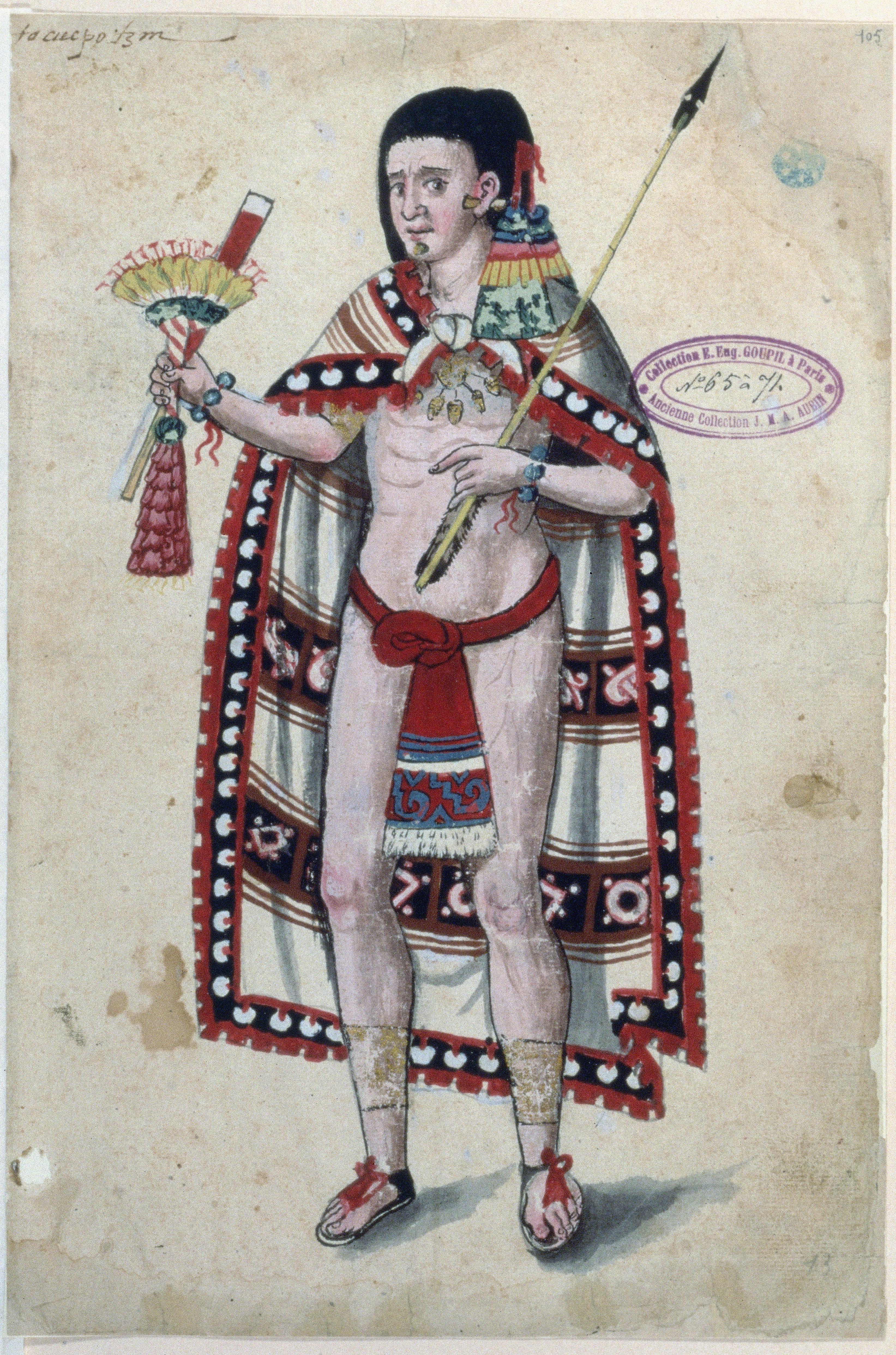
IMAGE 10: ‘Codex Ixtlilxochitl, Aztec Noble’, 1580-1584 CE. Current location: Bibliothèque Nationale de France, Paris, France. Description: “This figure of an Aztec noble, from a colonial manuscript painted in New Spain, emphasizes his elaborate regalia. His cape represents one sign of high status. Other accoutrements evoking his social position include his jewelry, gold anklets and feathered hair ornaments. Set against a blank ground, the noble appears today as part portrait, part specimen.” Dana Leibsohn and Barbara E. Mundy, Vistas: Visual Culture in Spanish America, 1520-1820, Vistas Gallery. Photo Credit: © Bibliothèque Nationale de France, 2003.
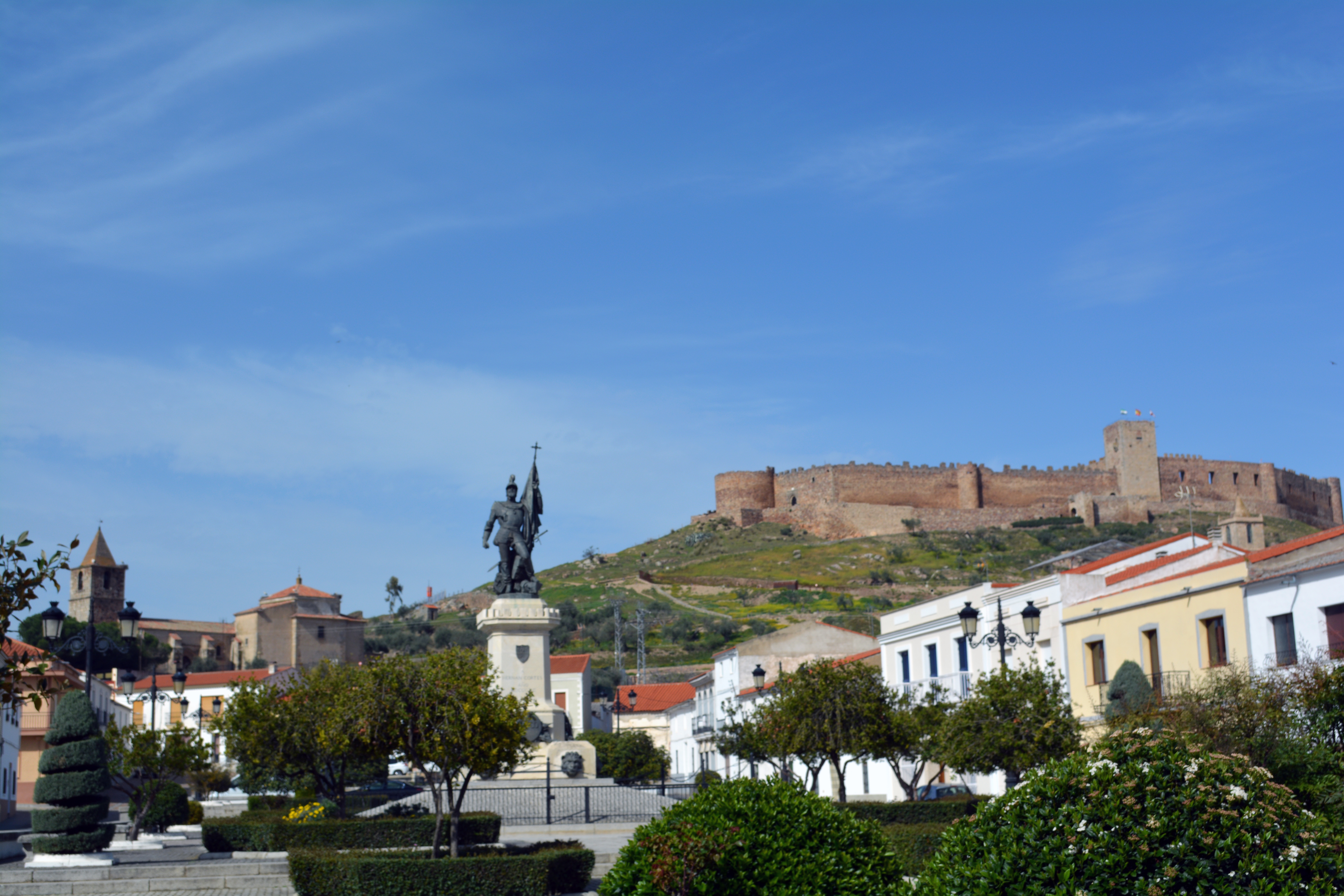
IMAGE 11: Medellín, Badajoz, Spain, birthplace of the conquistador Hernán Cortés. Photograph: David M. Carballo. Thank you to Prof. Carballo for providing this image.
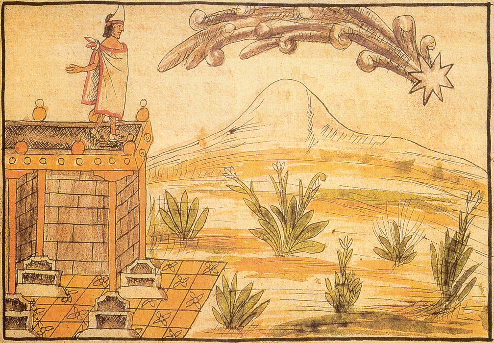
IMAGE 12: A retrospective portent of conquest? ‘Moctezuma views an ominous comet’. Diego Durán, Codex Durán (The History of the Indies of New Spain), c. 1581. Downloaded from Latin American Studies.
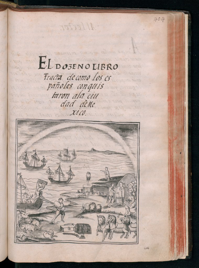
IMAGE 13: Title Page, showing the arrival of Hernán Cortés and his ships, men, and horses in Mexico. ‘General History of the Things of New Spain by Fray Bernardino de Sahagún: The Florentine Codex. Book XII: The Conquest of Mexico’, 1577. Description: “Historia general de las cosas de nueva España (General history of the things of New Spain) is an encyclopedic work about the people and culture of central Mexico compiled by Fray Bernardino de Sahagún (1499–1590), a Franciscan missionary who arrived in Mexico in 1529, eight years after completion of the Spanish conquest by Hernan Cortés. Commonly referred to as the Florentine Codex, the manuscript consists of 12 books devoted to different topics. Book XII recounts the Spanish conquest of Mexico, which took place between 1519, when Cortés landed on the coast with just over 100 men and a few horses, and 1521, when Tenochtitlan was taken and the Aztecs subjugated. The story is told from the perspective of indigenous elders who were living in Tenochtitlan at the time of the conquest and witnessed firsthand the events described. Sahagún gathered these accounts around 1553–55, when he was working at the College of Santa Cruz in Tlatelolco. The Nahuatl narrative begins with an evocation of the “signs and omens” that were said to have appeared before the arrival of the Spanish and concludes with the surrender of Tenochtitlan after an 80-day siege. By drawing upon primary accounts, Sahagún was able to capture the astonishment felt by the Aztecs and the trauma that followed their defeat at the hands of the Spanish. Among the key factors that determined the Spanish victory were the ruthlessness of the Spanish soldiers and of Cortés in particular, the use of horses and firearms, which the Mesoamericans had never seen, and Cortés’s intuition that the peoples of the Aztec Empire were prepared to join forces with him to shake off Aztec rule. Book XII contains numerous illustrations depicting scenes from the conquest, including the arrival of Cortés, an image of the Templo Mayor (Great Pyramid) in Tenochtitlan, battles between the indigenous people and the Spanish, and destruction of Aztec temples by the Spanish.” Physical Description: “Bound as part of volume 3. Ink on paper. 310 x 212 millimeters”. Biblioteca Medicea Laurenziana, Florence. Downloaded from the World Digital Library.
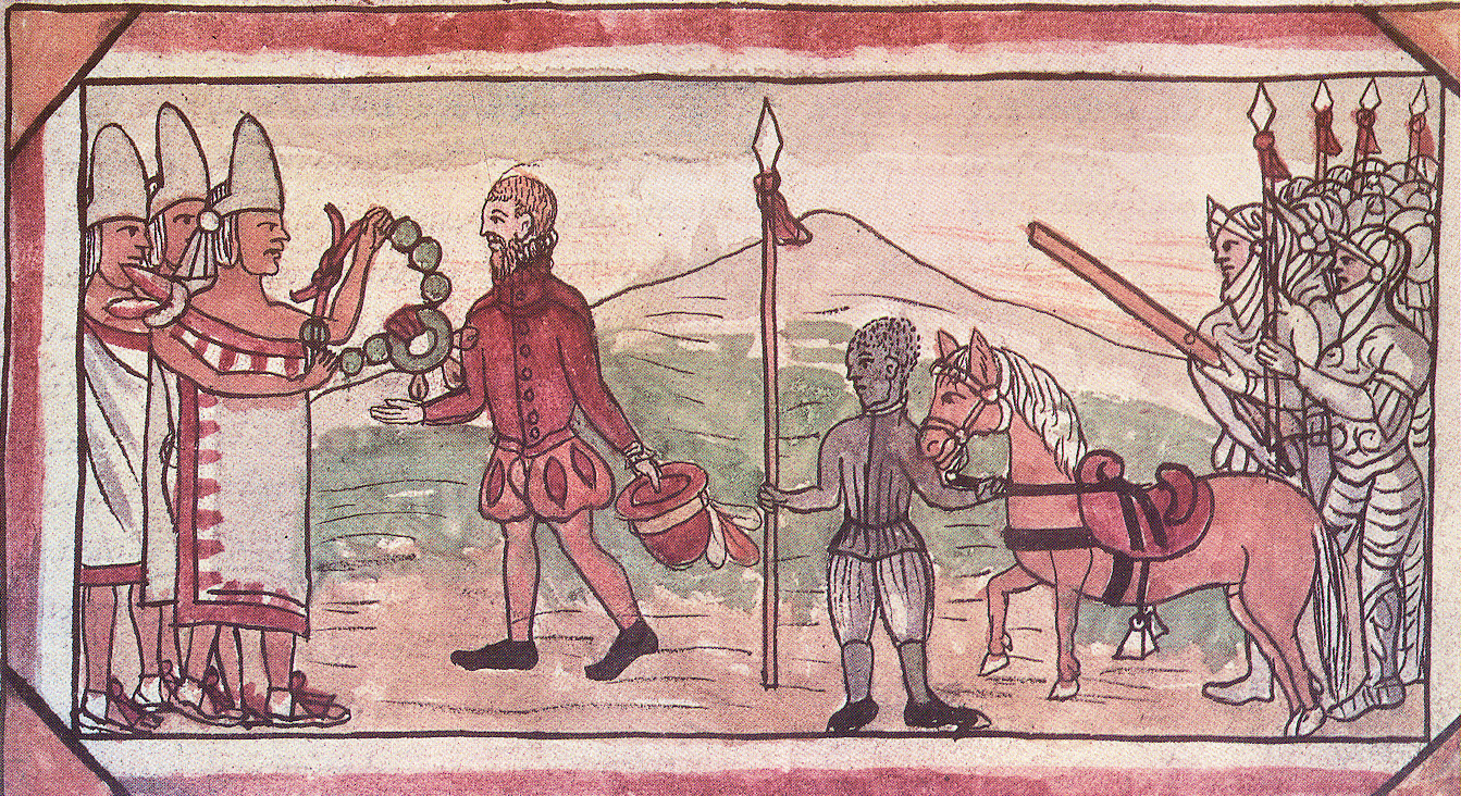
IMAGE 14: Objects and Encounter. ‘Cortes receives gifts from Moctezuma’s emissaries.’ Diego Durán, Codex Durán (The History of the Indies of New Spain), c. 1581. Downloaded from Latin American Studies.
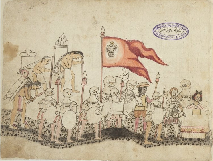
IMAGE 15: The importance of translation: Hernán Cortés marches with his army, porters, and his translator Malintzin (also known as La Malinche). He and Malintzin can be seen on the bottom-right of the image. Histoire mexicaine, dit “Codex Azcatítlan”, 1501-1600 CE. Bibliothèque Nationale de France, Paris, France, Département des Manuscrits. Mexicain 59-64. Format: European paper, 25 folios. Public Domain.
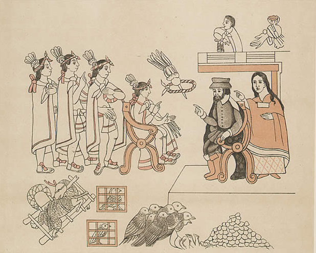
IMAGE 16: Translation and Encounter. ‘The meeting of Cortés and Moctezuma II, with Malinche acting as interpreter’, original: ca. 1550 CE, lithographic copy by Alfred Chavero (Homenaje á Cristóbal Colón: Antigüedades mexicanas), 1892. Description: ‘Tenochtitlan, Entrance of Hernan Cortes. Cortez and La Malinche meet Moctezuma II. November 8, 1519. The image is from the “Lienzo de Tlaxcala”, created by the Tlaxcalans to remind the Spanish of their loyalty to Castile and the importance of Tlaxcala during the Conquest. The text mixes European and native styles and includes anachronisms, such as the European-style chairs included in this image.’ Bancroft Library, University of California Berkeley, downloaded from Wikimedia Commons. Public Domain.
IMAGE 17: ‘Lienzo de Tlaxcala, Cortés greets Xicotencatl’, 1545-1555 CE. Current Location: Benson Latin American Collection, University of Texas, Austin. Description: “This scene depicts two famous alliances in the history of the Spanish conquest of the Aztecs. The first is between Xicotencatl, the head of the indigenous state of Tlaxcala, and Hernán Cortés, the leader of the Spanish conquistadors. The second alliance is that between Córtes and his translator, doña Marina, who appears in the center of the image.” Photo Credit: Benson Latin American Collection, University of Texas, Austin. Dana Leibsohn and Barbara E. Mundy, Vistas: Visual Culture in Spanish America, 1520-1820, Vistas Gallery.
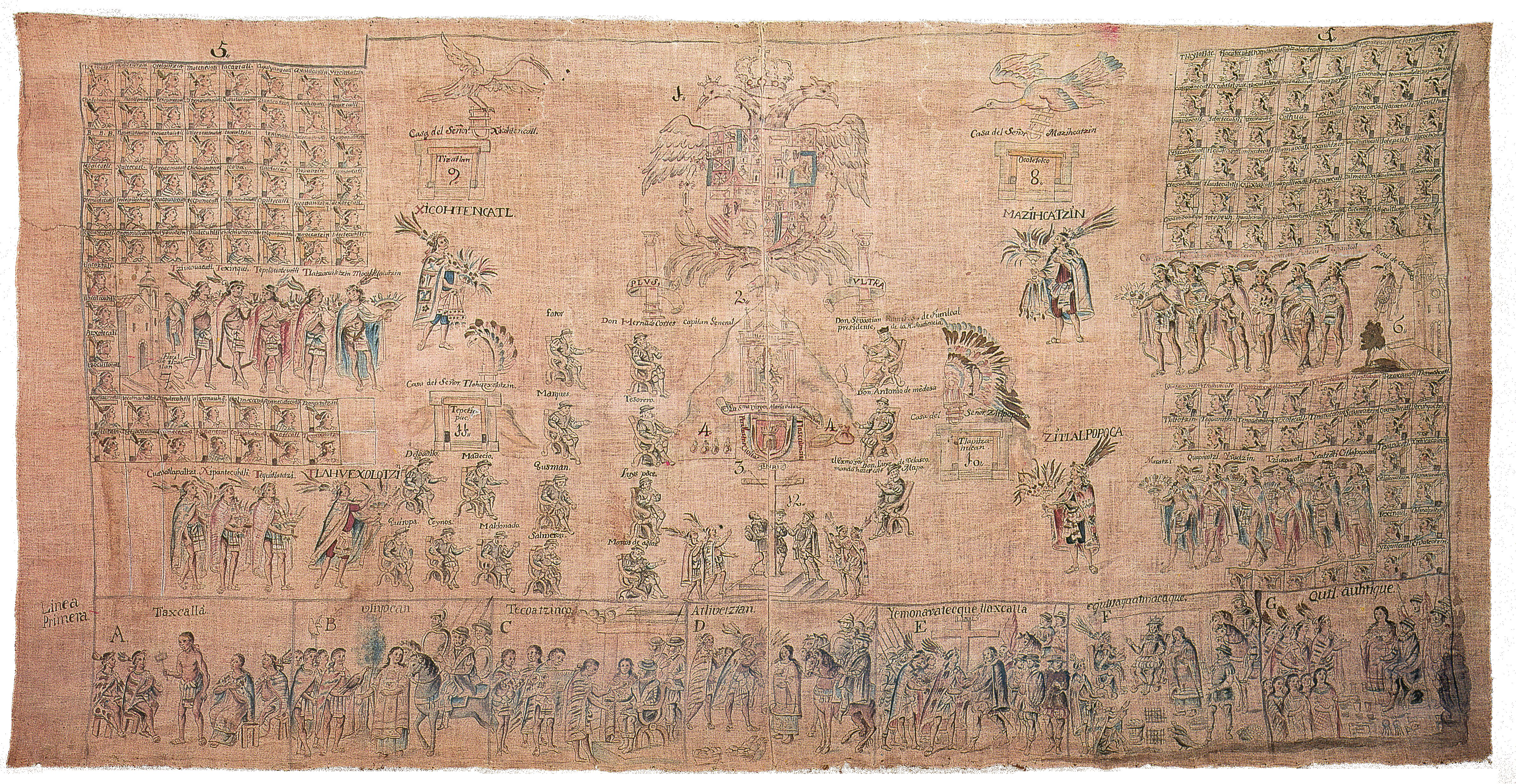
IMAGE 18: ‘Main scene of the 1773 copy of the Lienzo de Tlaxcala.’ Description: A copy [of the sixteenth-century lienzo] was painted in 1773, in an updated eighteenth-century style. Shading was used extensively in this copy to give bodies and draped clothing an appareance of three-dimensionality…In 1787 municipal official Nicolás Faustino Mazihcatzin y Calmecahua wrote an image-by-image description of the cloth, and said that it had been created during the reign of Viceroy don Luis de Velasco (1550-1564). Mazihcatzin also claimed that three copies once existed: one created to be sent across the Atlantic to the Emperor, one created to be sent to the Viceroy in Mexico City, and one to be kept in Tlaxcala. The 1773 copy still survives, housed in storage at the Museo Nacional de Antropología in Mexico City. The fate of the original cotton cloth (or cloths, if three were painted) is unclear. One was still in Tlaxcala until the 1860s. Then, during the French occupation of Mexico (1862 – 1867), the sixteenth-century Lienzo was taken from Tlaxcala to Mexico City so that a copy could be made by the French Scientific Commission, when the Emperor Maximilian was executed…[a]nd the French driven out, Tlaxcalan authorities tried to recover their stolen document. But it could not be found, and remains lost.’ Information and image from ‘Introduction to the Lienzo de Tlaxcala: History and Publications’, Mesolore.
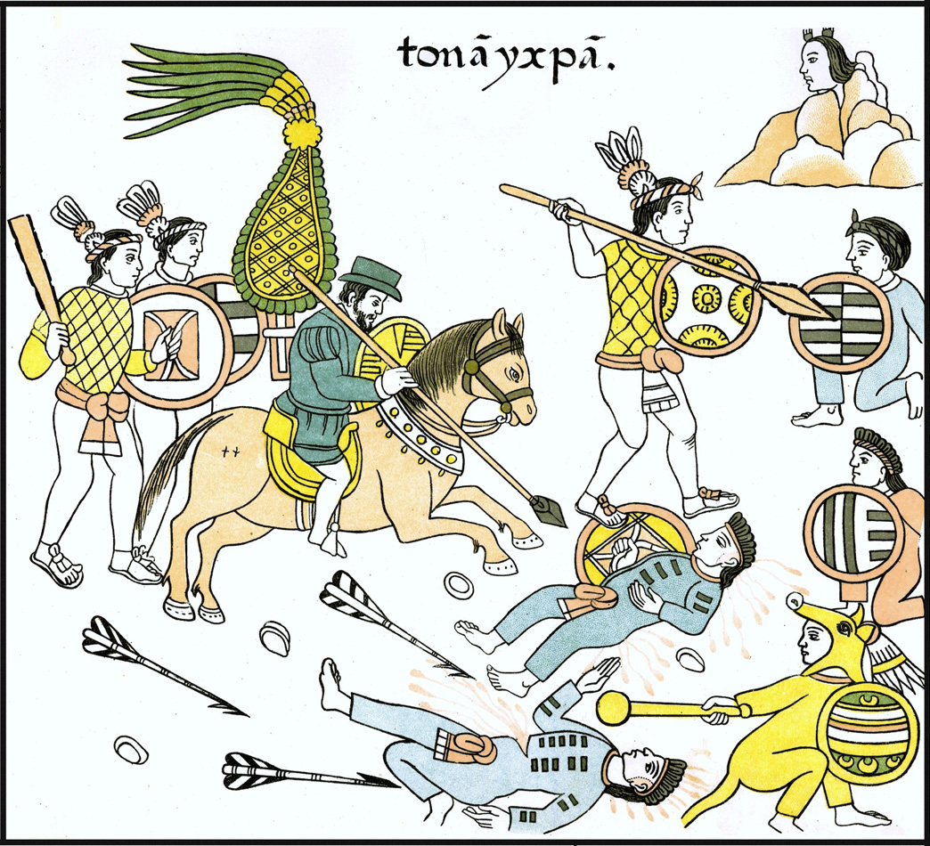
IMAGE 19: ‘Tlaxcalan warriors together with their [S]paniard allies. Lienzo de Tlaxcala. XVI Century’, lithographic copy by Alfred Chavero (Homenaje á Cristóbal Colón: Antigüedades mexicanas), 1892. Downloaded from Wikimedia Commons, which likely sourced its image from ‘Introduction to the Lienzo de Tlaxcala’, Mesolore: ‘Mesolore’s recreation of the Lienzo is made from digital scans of lithographs based on tracings taken from a cloth original.’
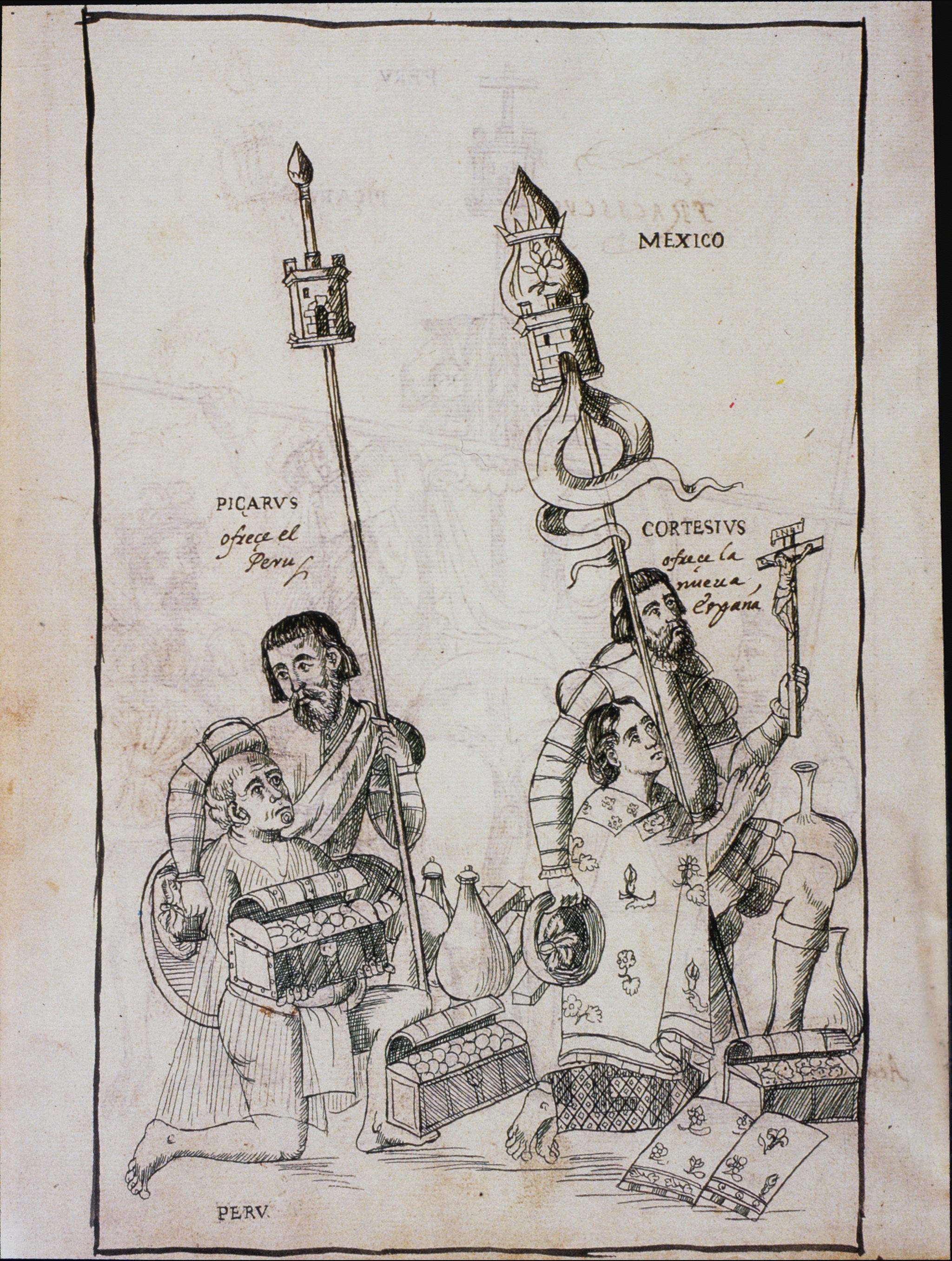
IMAGE 20: ‘Description of the City and Province of Tlaxcala, Pizarro offers Peru and Cortés offers Mexico [to the Spanish monarchs]’, 1581-1584 CE. Author: Diego Muñoz Camargo. Artist(s): Unknown. Current Location: Glasgow University Library, United Kingdom. Description: “This drawing comes from the history entitled, Description of the City and Province of Tlaxcala, written by Diego Muñoz Camargo (ca. 1529-99), a mestizo historian from New Spain. It shows an imagined scene where the Hernán Cortés, who conquered the Aztecs, and Francisco Pizarro, who fought the Inka, present their conquests, personified as a man and woman, to the Spanish kings, whose images appeared on the following pages. The Spaniards are historical individuals, but the native couple personifies the riches of the Americas, both material and spiritual: the native man presents a chest of coins, the woman prays before a crucifix. With arms wrapped around their charges, Cortés and Pizarro present this emblematic couple as their own offerings to the monarch.” Dana Leibsohn and Barbara E. Mundy, Vistas: Visual Culture in Spanish America, 1520-1820, Vistas Gallery. Photo Credit: Glasgow University Library.
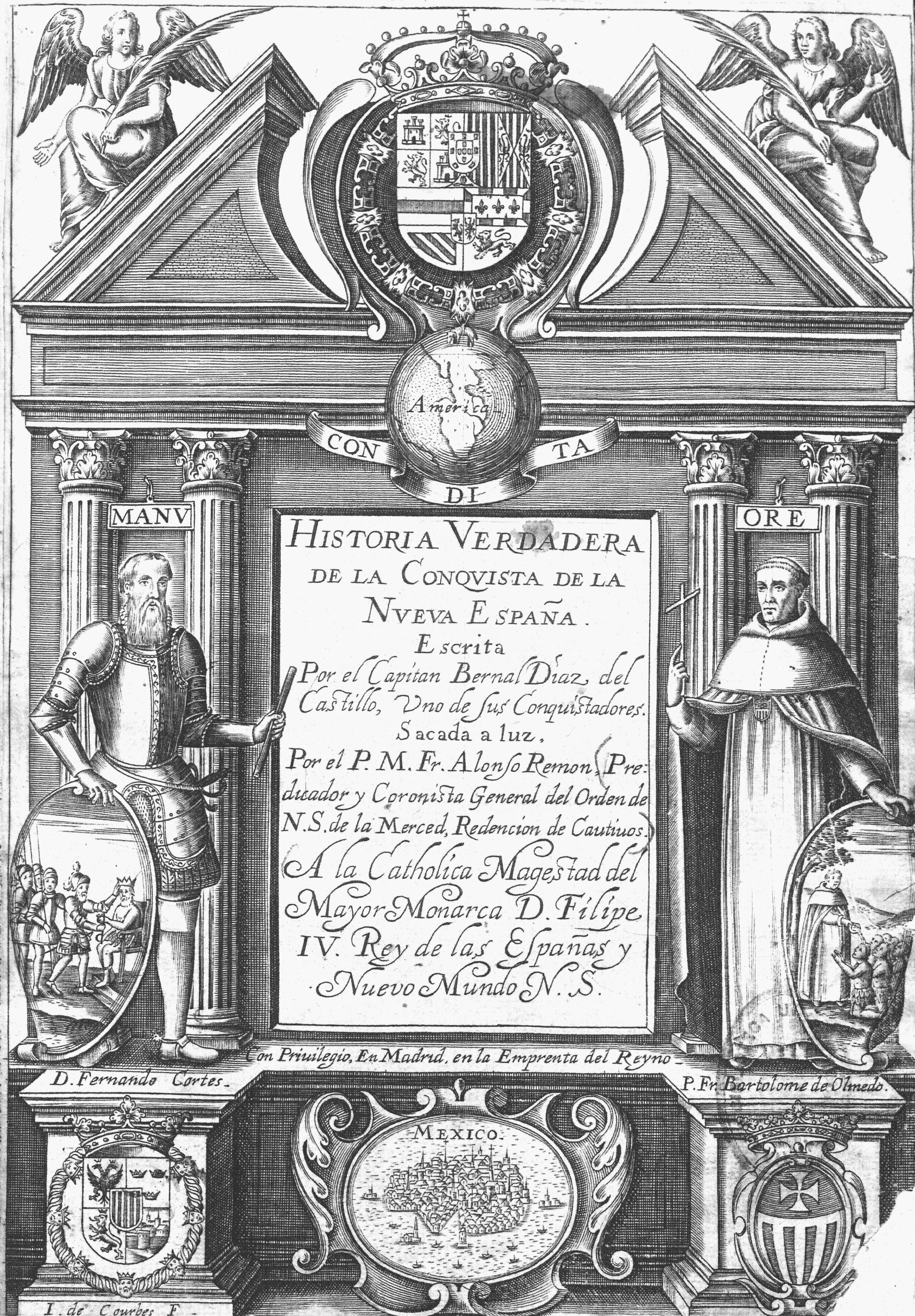
IMAGE 21: Title page, Historia verdadera de la conquista de la Nueva España (The True History of the Conquest of New Spain) (Madrid, 1632) ‘brought forth’ [edited from the manuscript] by Alonso Remón. Universidad de Sevilla, downloaded from Wikimedia Commons.
IMAGE 22: ‘Description of the City and Province of Tlaxcala, Burning of “idols”‘, 1581-1584 CE. Author: Diego Muñoz Camargo. Artist(s): Unknown. Current Location: Glasgow University Library, United Kingdom. Description: ‘This drawing comes from the history entitled, Description of the City and Province of Tlaxcala, written by Diego Muñoz Camargo (ca. 1529-99), a mestizo historian from New Spain. This page depicts the destruction of Aztec deity images and religious paraphernalia at the hands of Catholic friars in the 16th century, shortly after the Spanish conquest.’ Dana Leibsohn and Barbara E. Mundy, Vistas: Visual Culture in Spanish America, 1520-1820, Vistas Gallery. Photo Credit: Glasgow University Library.
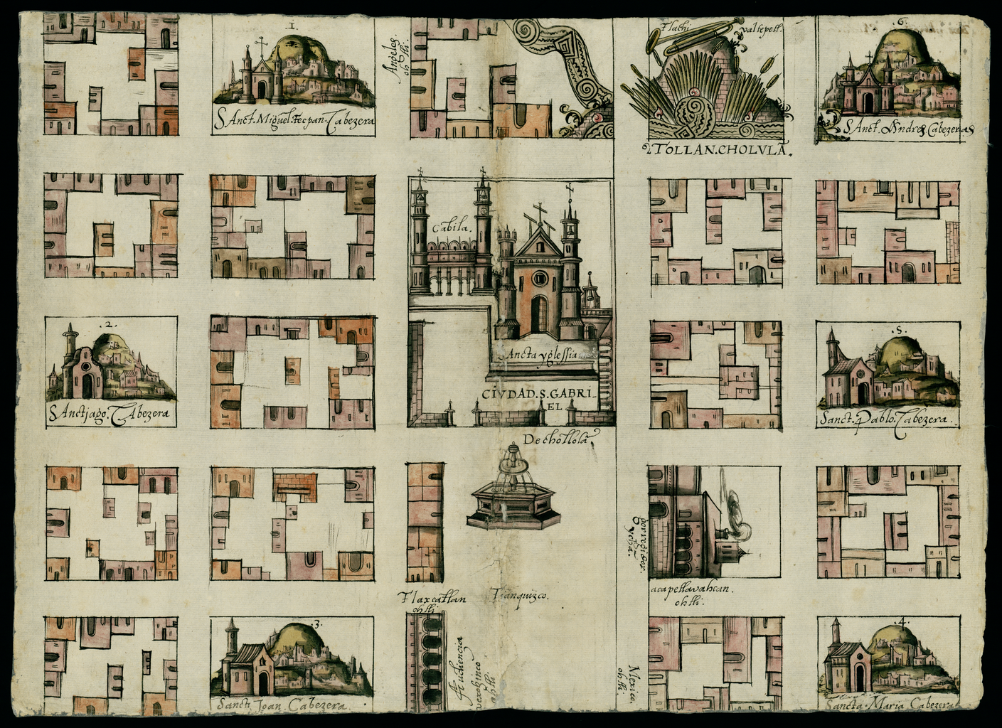
IMAGE 23: Map of Cholula, Tlaxcala Mexico, 1581. Relaciones Geográficas of Mexico and Guatemala, 1577-1585, Joaquín García Icazbalceta Manuscript Collection, Benson Latin American Collection, University of Texas at Austin. Description: “This map from Cholula in the present-day state of Puebla, Mexico, is from the Relaciones Geográficas collection in the Benson Latin American Collection at the University of Texas at Austin. Dating from between 1578 and 1586, the Relaciones Geográficas are responses to a questionnaire initiated by the Spanish crown in 1577, requesting information about Spanish-held territories in the Americas. The questionnaires covered such topics as demographics, political administration, languages spoken, physical terrain, and vegetation. The crown received 191 responses to these questionnaires. Of the 167 responses known to exist, 43 are in the Benson Latin American Collection. The others are held at the Archivo General de Indias, Seville, and the Real Academia de la Historia, Madrid. The relaciones contain important historical, cultural, and geographical information about New Spain during the 16th century. Many of the questionnaires are accompanied by maps and pictures. These both convey information about such topics as the colonial economy and the spread of European religion in New Spain and are artifacts for the study of the history of Latin American art and manuscript painting. This map dates from 1581 and has glosses in Nahuatl, the language of the Aztecs, and in Spanish.” Dimensions: 31 x 44 cm. Image downloaded from the World Digital Library.
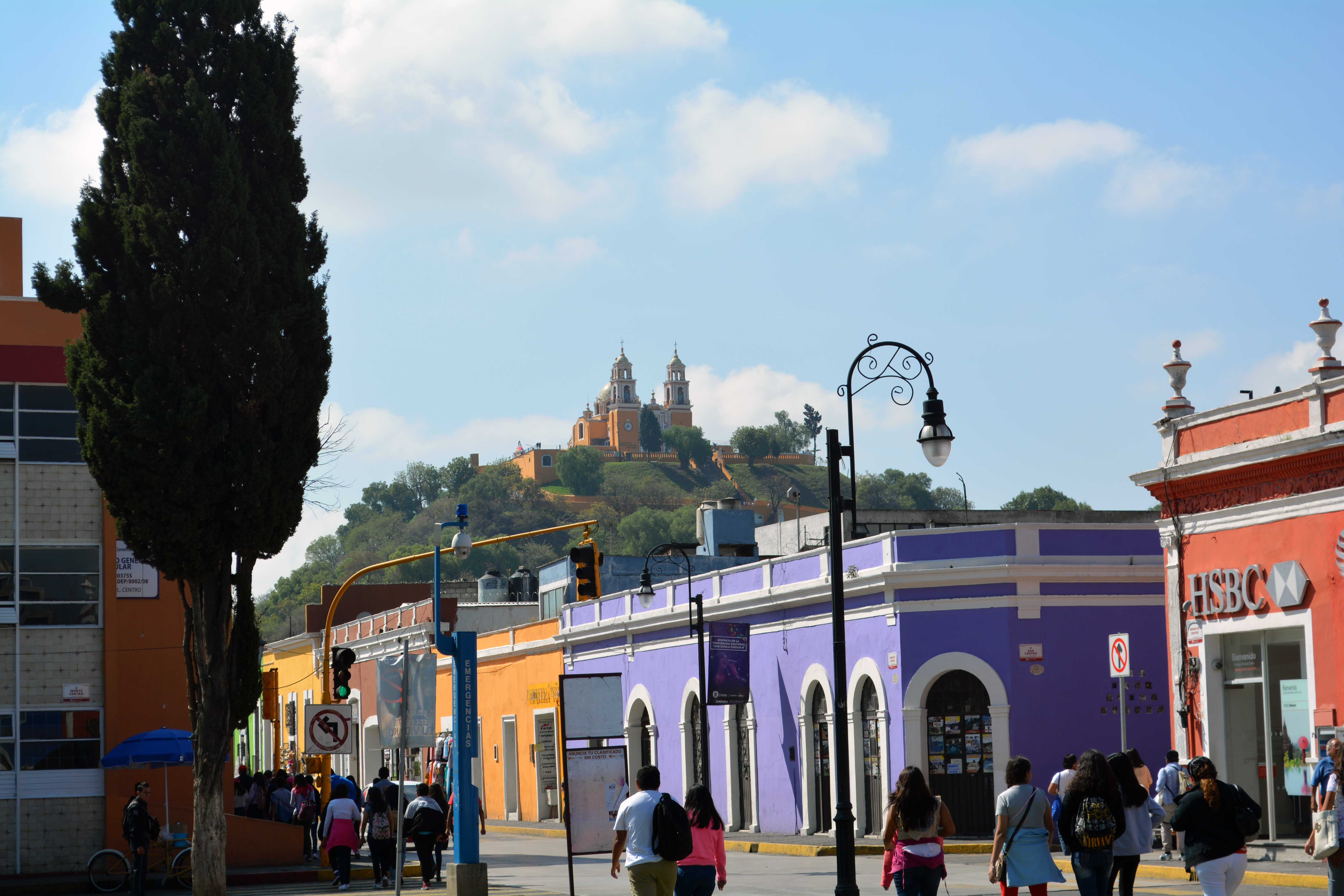
IMAGE 24: View of the Church of Nuestra Señora de los Remedios, built on top of the Great Pyramid in Cholula, Mexico. Description from Dana Leibsohn and Barbara E. Mundy, ‘Nuestra Señora de los Remedios, Cholula’, Vistas Gallery, Vistas: Visual Culture in Spanish America, 1520-1820 (2015): “About 70 miles from Mexico City, the Catholic church of Nuestra Señora de los Remedios crowns the huge mass of Cholula’s great pre-Hispanic pyramid complex, a sprawling set of plazas and pyramids built around the 10th century. By the 13th century, well before the arrival of the Spaniards, it seems to have fallen into disuse. 16th century Spanish observers said it looked like an overgrown hill….At the top of the pyramid, the church is dedicated to Our Lady of Mercy, the Virgin Mary as protector of the living and intercessor on behalf of souls. This church, finished in 1864, replaced an earlier one built in the 17th century. The great pyramid had a mud brick and rubble core and was once was covered by an exterior face of finished stonework. Its base has been partially reconstructed in modern times. The scale and formal design gives a sense of the sacred site’s built environment in its heyday….The great pyramid was the work of indigenous builders, working over centuries. Early mounds may have dated to the 1st century, the time that the metropolis of Teotihuacan was being built. The early earthworks still lie at the heart of the present pyramid, which was continuously enlarged over the centuries. After the conquest, the pyramid became the base for Catholic shrines. Some simple construction, perhaps merely a platform with a cross, seems to have been erected at the top of the pyramid by Cholula’s Franciscans in the 16th century. A larger chapel followed, finished in 1666. This chapel is recorded in 19th century engravings of the pyramid, but was replaced with the present church in 1864….Pre-Columbian architects aimed to create massive solid platforms upon which perched small sacred shrines. Their approach was quite different from that introduced by friars, which emphasized the creation of large interior spaces. The dismantling of the pyramid, begun in ancient times, continued under the Spaniards. Any extant cut facing stones were likely removed to build Cholula’s many 16th-century churches. The exposed mud brick eroded, and a map of Cholula from 1580 shows the pyramid’s base to be cut through by newly laid city streets….Cholula was a largely indigenous city through the colonial period, and once an important pre-Hispanic religious center, dedicated to the cult of the deity Quetzalcoatl. The pyramid below the church, which some believe may have been one of the largest of all pre-Hispanic constructions, was rebuilt several several times by pre-Columbian people and served as a pilgrimage site. Today, Cholula is famous for its large number of colonial-period churches—with each neighborhood having its own….For modern viewers, the sight of a church on a pyramid makes visible the imposition of Christianity on native religion. In the 16th and 17th centuries, particularly in indigenous towns, friars consciously tried to erase visible reminders of pre-Hispanic religion (and pre-Hispanic structures also were a convenient source for building materials). Unlike the great Templo Mayor in Mexico City, which was razed to street level, the great pyramid at Cholula was simply left as an overgrown ruin, eventually melding with the surrounding landscape.” Photograph: David M. Carballo. Thank you to Prof. Carballo for providing this image.
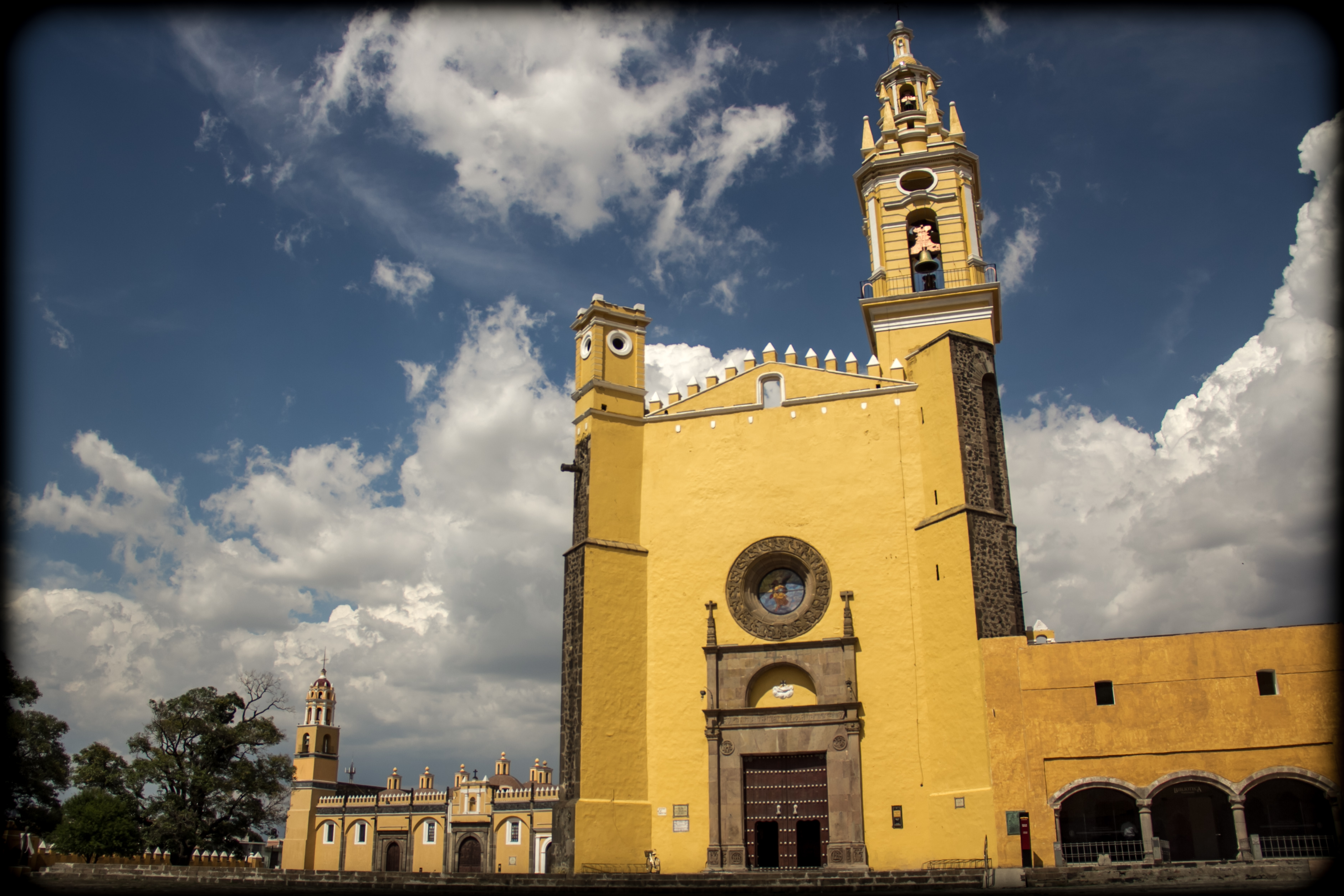
IMAGE 25: Church of San Gabriel, Cholula, Mexico, 1555-1570. Description from Dana Leibsohn and Barbara E. Mundy, ‘San Gabriel, Cholula’, Vistas Gallery, Vistas: Visual Culture in Spanish America, 1520-1820 (2015): “This sixteenth century “fortress church” was designed by Franciscan friars as part of their efforts to evangelize the Nahuas in Central Mexico. It was meant to replace the nearby pre-Hispanic pyramid as a center of religious and ritual life….Like most mendicant churches built in native communities, Cholula is a simple, single-nave church. The battlements at the roof were not literally for defense, although they may have been included to emphasize the metaphoric “military conquest” of New Spain. Above the main door, a pattern of carved flowers frames the deep-set round window. Its style reveals it to have been carved by a native artisan. To the left, the enormous Capilla Real (“Royal Chapel”) is the only one of its kind in New Spain. Its roof is supported by a forest of columns and its architecture most closely resembles the Great Mosque in Córdoba, Spain….San Gabriel was built by the Franciscans, who were charged with the evangelization of this densely populated region of central Mexico. Although some friars had training in architecture and engineering, they also relied on the skills of native builders to create the large, vaulted structures….The church is built of stone, brick and masonry. It was plastered and painted both inside and out. The interior vaulting systems used throughout to support the roof were European technology that the mendicant friars introduced to native builders. Since pre-Hispanic sacred architecture emphasized mass (great pyramids) rather than volume (interior space), such churches were as novel among 16th century Amerindians as the Christianity they sought to inspire….Between 1530 and 1580, mendicant friars commissioned hundreds of churches and dozens of larger monastic complexes like this one in New Spain. During its heyday, Cholula’s monastery buzzed with activity, as more than thirty friars taught native children from elite families within, and catechized adults in the outside courtyard. This same church complex appears at the center of the Relación Geográfica map from Cholula (also in Vistas), showing that other than the change in color, the building’s outward appearance has changed little over four hundred years….The Catholic church was deeply embedded into the fabric of urban life in Spanish America. Franciscans pointedly chose Choulua as a center for evangelization, since it was once a center for worship of the pre-Hispanic deity Quetzalcoatl, whose pyramid was mined for material to build the monastic complex. The hybrid styles of architecture in Cholula probably reflect the Franciscan understanding of their mission. For instance, the unusual side chapel looks like an Islamic mosque. In 16th century Spain, all mosques had been destroyed or converted into churches during the war of the Reconquista, as reminder of Christianity’s triumph over Islam. The Franciscans thought of their work in Cholula as another such religious conquest. Likewise, the battlements at the top of the building—which are decorative, not functional—added to the building’s metaphor of a conquering Christianity.” Photograph taken by Alexandro G. Alonso S. on June 27, 2013. Image downloaded from Wikimedia Commons.
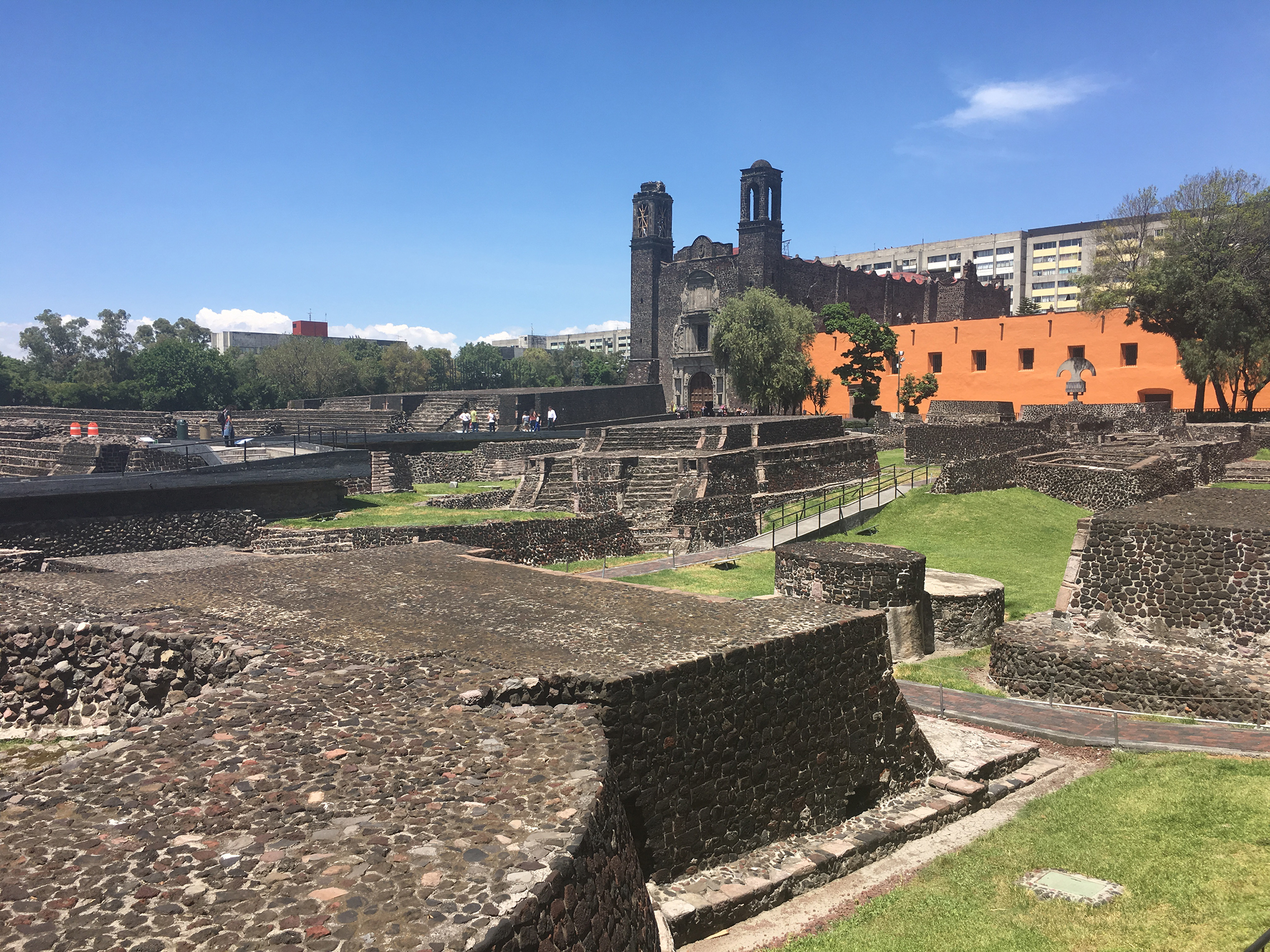
IMAGE 26: ‘Plaza of the Three Cultures at Tlatelolco: site of Cuauhtemoc’s surrender, the church of Santiago erected above the pre- Hispanic precinct, and Imperial College of Santa Cruz…where Sahagún worked with Mexica scribes’, in Collision of Worlds, Plate 5b. Photograph: David M. Carballo. The reproduction of this image in Collision of Worlds is authorized by the Instituto Nacional de Antropología e Historia, Mexico. Thank you to Prof. Carballo for providing this image.
IMAGE 27: Mudéjar ceiling, Church of San Francisco, Tlaxcala, Mexico. Photograph: David M. Carballo. Thank you to Prof. Carballo for providing this image.
IMAGE 28: ‘El primer milagro (“the first miracle”) depicting the Virgin of Guadalupe healing a Nahua actor after an accident in a September 26, 1531, mock battle between Toltec-Mexica and Chichimecs as part of the procession up the causeway between Mexico City and Tepeyac. Attributed to the workshop of José Júarez (1653)’, in Collision of Worlds, Plate 8. Thank you to Prof. Carballo for providing this image. Museo de la Basilica de Guadalupe.
IMAGE 29: An example of the transformation of Santiago in the New World, from Peru. Unknown Artist, ‘Santiago Mataindios’, 1700-1799. Material: oil on cloth. Painting school: Cuzqueña. Current location: Colección Celso Pastor, Lima, Peru. Image Source: Ilona Katzew, Contested Visions in the Spanish Colonial World (Los Angeles: Los Angeles County Museum of Art, Yale University Press, 2011). Spanish version: Miradas comparadas en los virreinatos de América (México: INAH, 2012), downloaded via ARCA®: Arte Colonial Americano. For an example from Mexico, see Dana Leibsohn and Barbara E. Mundy, ‘Santiago Matamoros’, Vistas Gallery, Vistas: Visual Culture in Spanish America, 1520-1820 (2015).
IMAGE 30: A changing Western Hemisphere. ‘Civitates orbis terrarum, Maps of Mexico City and Cuzco’, 1576. Creators: Georg Braun (editor; 1542-1622); Franz Hogenberg (mapmaker; 1535-1590). Current Location: Biblioteca Nacional, Madrid, Spain. Description: “This pair of maps of indigenous cities—one the capital of the Aztec empire, the other of the Inka—graced a luxury city atlas published in Europe. Both maps show the imperial cities as imagined by European viewers, not as they actually looked in the late 16th century. The printed page was the primary vehicle for information about the Americas to circulate in Europe, but because the Spanish crown protected information about its possessions, such publications were often fanciful or out of date.” Dana Leibsohn and Barbara E. Mundy, Vistas: Visual Culture in Spanish America, 1520-1820, Vistas Gallery. Photo Credit: Department of Special Collections, The Joseph Regenstein Library, University of Chicago.
IMAGE 31 Language of Empire. First Page from Antonio de Nebrija, Gramática de la lengua castellana (Grammar of the Castilian Language) (Salamanca, Juan de Porras, 1492). Description: “Presented here is the first grammar of the Castilian language. This is also the first grammar of any vernacular language to be printed in Europe. The book was published in 1492, at a time when Castilian was still not considered a “language of culture.” The author, Antonio de Nebrija (circa 1444−1522), had previously written an Introductiones latinae (Introduction to Latin). He concluded that students would be better able to study Latin if there were established rules for their native language of Castilian and if they were taught these rules. The work is divided into five books: “Orthography,” “Prosody,” “Etymology,” “Syntax,” and “Introductions to the Castilian language for those of a foreign tongue who want to learn.” The text is printed in Gothic type with black ink. The first page is printed in red and black. The blank spaces throughout were reserved for enlarged initials, which were never added.” Biblioteca Nacional de España. Downloaded from the World Digital Library.
IMAGE 32: Mexico, Between Pacific and Atlantic Worlds. ‘Jar’, Place of origin: made in Puebla, around 1700. Materials and Techniques: Tin-glazed earthenware. Credit Line: Bequeathed by A. P. Maudslay. Museum number: C.33-1931. Gallery location: Ceramics, Room 145, case 48. Dimensions: Height: 47.6 cm, Diameter: 34.9 cm. Physical Description: “Large earthenware storage jar with tin-glazed decoration in blue and white in Chinese style. A drilled hole in the lower part of the side, probably added to fit a tap.” Summary: “Spanish potters introduced the potters-wheel and tin-glazing technology to Mexico in the early 16th century. Mexico City and Puebla became the centres for ceramic production. Initially Mexican tin-glazed ceramics were strongly influenced by Spanish maiolica pottery. In 1565 Spain established a new trade from China to compete with Portuguese merchants. Cargoes of Chinese porcelain were shipped across the Pacific Ocean to Mexico, where they were carried overland via Puebla before being shipped on to Spain. These Chinese exports strongly influenced local potters, who combined Chinese blue-and-white decorative schemes with uniquely Mexican features, such as the distinctive quetzal bird motif.” Ceramics Collection, Victoria and Albert Museum, London, United Kingdom.
IMAGE 33: Remembering the Conquest on a Japanese-inspired folding screen. ‘Biombo, Conquest of Tenochtitlan’, 1675-1700, unknown creator. Current Location: Museo Franz Mayer, Mexico City, Mexico. Description: “This folded screen presents a then-and-now view of Mexico City. On this side, the city is in the throes of the fiery wars of conquest in 1520-21. On the other is the peaceful 17th-century city, with the Viceregal palace at its center….The painter depicted the same space of Mexico City on both sides of the biombo. On this side, the notable events of the conquest unfold. The conquest narrative begins at the upper right, as Hernán Cortés is welcomed into Tenochtitlan by the emperor Moteuczoma. Behind his palanquin is an even grander one, presumably to seat Cortés. Along the central axis is the main plaza where fierce fighting took place for control of the city. Beneath is a scene showing the assassination of Moteuczoma. The painter makes clear that it was angry Aztecs, not Spaniards, who were responsible. At one point during the war, the Spanish were routed from the city. The dark lower right corner obscures their flight, the low point of Spanish fortunes in the war….While its original setting is not known, the biombo most likely adorned a large room in a wealthy urban home in Mexico City. When unfolded to reveal its two distinct views of the city, the biombo may well have become a conversation piece—stimulating talk of the city and its past….The biombo offers one picture of how elites in New Spain understood the wars of Conquest, and their interpretation of these events. Instead of a foreign usurper, Hernán Cortés is shown as a welcomed savior. And Aztecs, not Spaniards, are shown as responsible for the assassination of Moteuczoma, an act which brought autonomous indigenous rule to an end.” Dana Leibsohn and Barbara E. Mundy, Vistas: Visual Culture in Spanish America, 1520-1820, Vistas Gallery. Photo Credit: Museo Franz Mayer.
IMAGE 34: A Changing Mexican Capital. ‘Biombo, Scene of Mexico City’, 1675-1700, unknown creator. Current Location: Museo Franz Mayer, Mexico City, Mexico. Description: “This folded screen presents a then-and-now view of Mexico City. This oblique view from the east of the city depicts 17th century Mexico City as a peaceful place, with the Viceregal palace at its center. This standing screen was created in Mexico, although the format—of painted panels that could fold or extend into space—was introduced into New Spain from Japan….This view of 17th century Mexico City gives little evidence that the Spanish colonial city stood directly atop Aztec Tenochtitlan. The great Templo Mayor once stood slightly to the west of the site of the Cathedral, the large building directly to the right of the central axis of the biombo. Adjacent to the Cathedral, one can see the façade of the Viceregal place, which, ironically, would be burned by mobs in 1692, angered over the escalating price of maize. The palace, home to the Viceroy, stood on the same site as the palace of Moteuczoma, the last Aztec emperor. The rectangular blocks of the carefully planned city were filled with buildings to the street line. Central courtyards allowed light and air to enter interior rooms. The painter has compressed the view of the city to include the shrine of the Virgin of Guadalupe, seen in the upper left corner. Built adjacent to a former shrine to an Aztec earth goddess, the basilica held a miraculous cloak with the Virgin’s image, revered by indigenous people and Creoles alike. A hallmark of successful government was the ability to supply fresh water to city residents. Dominating the right foreground is the curving line of the aqueduct from the springs at Chapultepec”. Dana Leibsohn and Barbara E. Mundy, Vistas: Visual Culture in Spanish America, 1520-1820, Vistas Gallery. Photo Credit: Museo Franz Mayer.
